I’m outside, enjoying another beautiful, sunny day. Soon, my sister and brother-in-law will be here for a 4 day visit all surrounding my upcoming birthday on the 21st. We’re having a celebration Saturday with about 16 family members and friends–17 if you count Erik. It should be fun. That being said, I won’t be posting until Tuesday because I want to spend as much time as I can with family. Have a great weekend!
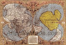
Me: Erik, I’d like to ask you about this map. It’s one I’ve heard about. It’s called the Piri Reis map. It’s dated at around 300 A.D., and the thing about it is that it shows South America in a very accurate position in relationship to Africa, and the western coast of Northern Africa and Europe and the Eastern coast of Brazil are really depicted beautifully. I think the most astonishing thing is that a partial view of a continent that we now know is Antarctica, but that’s yet to be discovered. It wasn’t discovered until 1820. The most puzzling is that it’s shown without ice in vivid detail yet the land mass has been covered with ice for at least 6,000 years. We do know what the land mass looks like now and the map portrays that even though it’s now covered with ice. What’s that all about?
Erik: It’s not forgery. By the way, I want to say to everyone who’s watching, and hi to my mom.
Me: Hi, baby.
Jamie: He’s sitting behind the camera today, and I hope he’s not going to cause any interference.
Me: Yeah, he gave you a nice smell this morning, didn’t he?
Jamie: He did, and it wasn’t on me. It was in the air like somebody spritzes it like perfume.
Me: Erik, you might want to consider perfume or roses.
His signature smells are nasty.
Erik: That wouldn’t be my style.
Me: No, it wouldn’t be. So, what’s up, Erik? What’s up about this map?
Erik: It’s not a fraud. (He sits back in his chair and folds his arms.) You know, we’ve all known about strange weather patterns. Scientists can say that the land mass had been covered my ice for x amount of years, but there are always freaks of nature.
Me (teasing): Like you, Erik!
Jamie (laughing): He said something similar about you!
Me: Oh!
Jamie: I told him I’m not saying that, and then you said it. That was funny. Anyway—
Erik: I find it really disappointing that history depicts landmasses with power. The ego driven knowledge that we have now is based on power, money, blah, blah, blah. It’s just not right because we have so much proof that even the Vikings were in the middle of what we call the United States today hundreds of years before it was air quotes) “discovered” by Christopher Columbus. Why do we even use the words, “discovered by” when Native Americans or “first land people” for centuries before he even showed up? It’s just warped. The English language sucks. The map, totally a real thing. So what do you want to know about?
Me: Well, how was it created? It’s almost like it had to be an aerial view. Well, maybe not. It’s just, how could it have been that long ago?
Erik: Come on. Think about it. There are so many talented artists—
Jamie stumbles over the word, “artists,” and then tells him, “Thank quoi for teasing me!”
Erik: You don’t have to have an aerial view to really depict it 3-D or in the shape of a barge landmass. There are brilliant people out there, and of course, and, Mom, the people who are interested in going out and mapping what their environment looks like on that grand of a scale, it’s going to be someone who’s passionate and extremely interested in documenting it. Are you trying to elude—
Jamie (laughing): He kind of runs his hands through his hair like a girl.
Me: Big word!
Erik: Are you trying to allude to the fact that aliens were involved? Obviously we didn’t have flying spaceships or airplanes back then.
Me: Well, yeah, I maybe thought it was possible. How could they travel all the way to, I mean, what kind of vessels could they possibly have that could travel all the way to Antarctica and all around the world?
Erik: Mom, are you kidding me? Have you looked at the designs of the ships they had back then? Yeah, they might have been shallow, and that’s kind of messed up. They had—
Jamie: He’s showing me pictures. They look like very long canoes like oversized one. He’s showing me islands—
(Pause)
Jamie: Oh, Erik, can’t you just talk to me without pictures? He’s showing islands and they go from islands to island and map islands halfway around the world and know about the seasons by how the water would roll in and roll out (Tides, obviously) and with the storms that would come. Like we know, today, when a hurricane is coming. They had this knowledge, too.
Erik: Why are we even thinking that because people were alive so long ago that they had to be stupid and that our evolution and who we are today absolutely exceeds their knowledge?
Me: Well, let’s face it. We have radar.
Erik: That’s exactly my point because they didn’t have radars back then, they gained that knowledge internally. Birds totally kick ass. They can navigate themselves anywhere around the world. Whir makes us thing that humans have less capability than the bird? Come on, Mom. Seriously. If you didn’t have your TV or iPad or your phone, you’d still know where the birds were going to go, and explorers would follow that migration and pay attention.
Me: Is there some sort of magnetic navigation? Is it an ability that we don’t have now or that we don’t use now? Birds don’t go, “Hey, which way is the wind blowing? Hey, where are you going, Bob? I think I’ll go with you.”
Erik: They used stars and the mapping of weather patterns and used calendar years. It was all based on migration behavior and patterns, stars, etc. What you have, talking about this map—You’re so cute. You printed out a copy.
Me: How did you know that!
Of course I know how. I just love the confirmation.
Erik: It wasn’t done by some interdimensional being. There was no help by aliens. It was done by very creative, passionate explorers on Earth, and it’s an accurate map.
Me: Why did the do this? Was there any purpose besides, “Hey, let’s see what’s shaking down in North Africa.”
Erik: Yeah, Mom. That’s exactly what they said.
I detect a note of sarcasm.
Me: Okay. Where did they start?
Jamie: He’s showing me, oh my god, I wish I had a map, He’s showing me north of Europe east of England.
Me: Greenland? It can’t be that, I’m sure. The Faroe Islands?
Jamie: He’s just showing me it’s all up there.
Me: Is it west of Scandinavia?
Jamie: Can you go north of Scandinavia?
Me: Yeah. That’s where Santa Claus lives.
Jamie laughs.
Me: No, I can’t remember, but I think there’s like the Faroe Islands. So somewhere in that region. Interesting.
Erik: The frozen boat people.
Jamie: So it had to be a place with long winters.
Erik: It was their natural instinct to go out and explore, but a lot of what they would do, not many of them would return.
Me: I bet not. Well they put it on Gazelle skin so it wouldn’t be one of the Polynesian islands. That makes sense. I wonder if they were related to the Laplanders in Finland and Northern Norway.
This would make some sense since these people are nomads.
Erik: Cha ching.
Me: Because they looked kind of Asian.
I guess I’m referring to the fact that they must have traveled far to stray from the intuits and other Asian populations.
Me: Okay. Anything else, Erik?
Erik: Nope. I just challenge everyone else to figure out what they believe and know. They need to make their own truth.
The Piri Reis Map